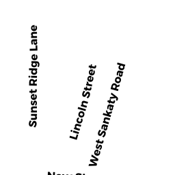
12- LINCOLN SIAS ST
Owner Information
GRAF JOHN A & MAUREEN K
2607 PEMBERTON DRIVE
HOUSTON, TX 77005


Property Details
12- LINCOLN SIAS ST is classified as a Developable Residential Land (Vacant land).
12- LINCOLN SIAS ST is valued at $705,100. The land is valued at $705,100 and the structures are valued at $0.
This property is in Zone SR1. Confirm with local Zoning Board authorities to ensure there are no overlays or other easements on this property.
The most recent deed for 12- LINCOLN SIAS ST is recorded at the local registrar in Book 01207, Page 0251. 12- LINCOLN SIAS ST was last sold on Thursday, November 19, 2009 for $2,900,000.
Assessment data from fiscal year 2022.
Flood Data
According to the FEMA National Flood Hazard Layer, this property does not appear to be in a flood zone. It may also be in an area not yet reviewed. Nonetheless, confirm this information prior to taking any action.
To view the flood hazards around this property, create a FEMA "Firmette" Map of the area around 12- LINCOLN SIAS ST.
Broadband Internet Providers
| Provider | Type | Bandwidth (mbps) | |
|---|---|---|---|
| GCI Communication Corp. | Satellite | 0 | 0 |
| Comcast | Cable | 1000 | 35 |
| Verizon New England Inc. | DSL | 15 | 1 |
| VSAT Systems, LLC. | Satellite | 2 | 1 |
| HughesNet | Satellite | 25 | 3 |
| Viasat Inc | Satellite | 35 | 3 |
| Crown Castle Fiber | Fiber | 0 | 0 |
Broadband service provider data from December 2020.
Adjacent Properties
- 16 LINCOLN SIAS ST
Multiple Houses on one parcel owned by BENSON MARLENE J TRST - 7 SUNSET RIDGE LN
Single Family Residential owned by 7 SUNSET RIDGE LLC - 10 LINCOLN SIAS ST
Single Family Residential owned by ROSS NINA L & BERMINGHAM NESSAN A - 14 LINCOLN SIAS ST
Single Family Residential owned by GRAF JOHN A & MAUREEN K